Posts Tagged ‘ directions ’

For those about to walk, we solute you!

Posted on May 14th, 2009 Comments Off on For those about to walk, we solute you!

Walking. Is there anything better?

I’m fairly certain I’ve mentioned this before but walking around the city is the cat’s puss.

Not only do you not have to hunt down and maim ever-scarcer parking (the fight with the rival in front of the spot is the maim part), but you don’t even have to find a pole to strap your bike to. You wanna go there, you just go!

Also, it allows you to meet up with fellow walking enthusiasts like the pleasant young Brazilian ladies I played tour guide to today. No matter what angle you looked at that walking from, it looked really good. (I must apologize, I’ve been extremely negligent in my duty to carry a camera. I will try to rectify the situation post-haste.)

I probably shouldn’t go any farther with that, I blush easily. But I will say that my zeal for walking has been greatly rejuvenated. The tourists are sometimes just as, if not more, interesting than the natives. And they’re just walking around like it’s nobody’s business. Awesome!

In a way, we kind of owe much of this to map makers. Especially those who produce maps for tourists. Most of the visitors are on foot while the maps are focused on streets. Great if you’re in a car, but not very informational for someone who can travel a much wider area on foot.

A while ago I was toying with the idea of how a walking map might be different from a driving map. What kind of data should be on there that already isn’t and would also be useful to pedestrians?

Well, for one, I thought, why not mark all areas that are accessible to pedestrians? Lots that can be walked through; breaks between buildings that are not roads (pedestrian alleys); paths through buildings that are generally open to the public (why go around when you can go through?); that kind of stuff.

Here’s an example where the green overlay demonstrates all pedestrian accessible areas.

map

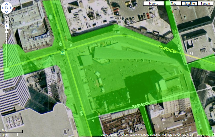
That covers a lot more ground than a car, even though this map is actually missing a lot of detail; areas indoors and under/over the ground that you could also use to get around, for starters.

Meh. It’s Thursday.

I saw an example walking map in Spacing Wire a while ago but grading sidewalks as “pleasant” or “unpleasant” struck me as genuinely useless. I personally found some of their “unpleasant” sections extremely enjoyable. You’d think for a magazine dedicated to thinking about such stuff, they would’ve had a few good ideas.

Now, as regards the tourist population of the city, I’m not suggesting that we would ever export such maps; what I’m thinking is that we use the guides domestically to give the appearance of being extremely knowledgeable about the city. Breaking the ice could be as simple as, “Hey! Can I show you around in that alley back there!”

Filed under: B Sides, Pictures

Corpulence or giant balls of steel?

Posted on May 13th, 2009 1 Comment

The more I walk through downtown Toronto, the more I’m convinced that the city is really going downhill.

Let me explain using of an illustration. For this you need to think B-I-G.

First envision a fat person, I mean really big; the kind of extended circumference for which the words “morbidly obese” barely scratch the surface; the kind of rotund that results in, basically, a giant ball with tiny projections that were once the appendages.

This person would have fashioned for them a sturdy steel girdle that would encircle their girth and provide a hard outter support for the gelatinous mass underneath.

Now take this person, somehow, to a place on Yonge street just south of Highway 401; some spot on the road with a good decline. This last part is crucial because it is this hill that would impart the required momentum to our gargantuan friend.

With the girdle supporting the ball’s innards (the person would be on their side), all it should need is a good strong push and…see you in the lake!

The momentum gained on the first hill, coupled with the sheer weight of our subject, should be enough to overcome the minor dimples and valleys along Yonge street and land him or her in the sparkling waters of the lake.

This is due to the simple fact that Toronto literally moves downward as it moves south. As you travel in this direction along most of the major city streets, you can see the foundations of buildings growing taller in order to keep the structures level. And it isn’t slight either; most buildings will have an extra three or four feet added to them at their southern end.

As long as our massive abomination continues to roll in a straight line, there should always be more downward hill further along to speed his or her progress.

I suppose this experiment could also work with a giant steel ball or a heavy car. I suppose.

Whether it’s corpulence or giant balls of steel, in Toronto all will roll down as they roll south. When you go downtown, you will really be going down to town. And if you wish to travel down south, you will also be generally correct (it’s a little south-east, really).

Besides this natural wayfinding feature, the city also has a grid layout that can either be hindrance or a real time saver.

Because of the unsightly bulge in the southern end of the city core, a number of the roads that run close to the waterfront have to either veer north or simply end. King and Queen streets, for example, run roughly parallel until they join together at Roncesvalles in the west. As they separate in the eastbound direction, the move further apart and new streets like Adelaide and Richmond rump up the increasing space between them.

So if you’re travelling west and south through the city, don’t bother with the south part. Most streets go south-west already.

I remember working at an ill-fated coffee shop in the base of the Toronto Reference Library many years ago. A gentleman came in and purchased a small cup of coffee, took a sip, instantly ingratiated himself with me by complaining about how weak Canadian coffee was, and then asked directions to the nearest Canadian Tire.

I told him it was just north of us.

“What is it with this north south crap with you Canadians? You all carry a compass or something?”, he half-joked.

“Never eat shredded wheat, biatch!”, I replied.

Well, biatch wasn’t a word at that time; but I wish I’d said that!

(…for those of you who recognized Kirby from the front cover — when I used front covers, you may enjoy this greeting card: http://gaygamer.net/images/kirby.jpg — DO NOT ask how I ended up on that site.)

Filed under: B Sides, Pictures